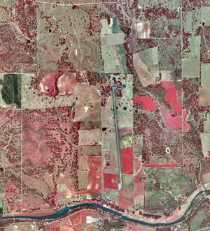
This is an infrared aerial photo of Lyndon B. Johnson National Historical Park. Colors are used to show different areas of the picture. Generally red tones in color infrared aerial photographs are associated with live vegetation and the tone of red can be used to monitor the density and health of the vegetation.
Wednesday, August 6, 2008
Doppler Radar
Flow Map
This flow map uses color, shading, and directional lines to show the flow of air traffic at King County International Airport in relation to their Fly Quiet program. The directional lines show where an airplane will fly over noise sensitive areas so that the pilot will know where he/she would need to follow the Fly Quiet regulations.
Isoline Map
Proportional Circle Map
http://cache.search.yahoo.net/search/cache?ei=UTF-8&p=proportional+circle+map&fr=yfp-t-501&u=www.neiu.edu/%7Enerobert/Cartography.htm&w=proportional+circle+circles+map+maps&d=YttYDRg5RKVu&icp=1&.intl=us
Hypsometric Map
PLSS Map
http://welcome.warnercnr.colostate.edu/class_info/nr502/lg3/graphics/plss_basemap_washing.gif
Subscribe to:
Posts (Atom)